Muddy Fork to Lost Lake
Day 3, Muddy Fork to Lost Lake: 11.8 + 3.4 miles
The morning came and we found that another of the Janes had left the group (leaving just the one who seemed to have a thing for Ryan). We figured she’d hang on a little longer. We broke camp and headed up a dry and rocky creek bed towards the river crossing. It wasn’t really any less scary in the morning. Ryan had to be manly so he boldly leaped from rock to rock and crossed quickly while I was more gallant and carefully carried Karen across the river. Safely on the other side we found more rocky scrambling to be done and then found a steep bank of loose scree down to an even more raging river. This time Ryan let me carry Karen across first. I assume he did this so that he could see how I picked my path. I managed to get across without Karen or our packs getting wet though I was pretty soaked up to the waist. Ryan came behind and we were all thankful to be done with all the hazardous crossings on our route.
We climbed up out of the valley towards Bald Mountain. We continued to get great views of Mt. Hood though the air was pretty hazy from the smoke blowing over from the forest fire on the east side of the mountain. We had been hoping to take the Timberline Trail up to McNeil point to do some letterboxing and then camp at Lolo Pass. This would work out well as it would have us camping just north of the Bull Run Watershed where no camping is allowed for a nine mile stretch of the PCT. But we found the trail closed for the fire. We had anticipated this possibility from the last report we had but we hoped to go up the trail anyway. An armed kid wearing a National Guard uniform at the trail intersection spoiled that plan. We didn’t really have a plan B: stopping at Lolo Pass would make for a shorter day than we wanted and the next known campsite would make for an 18+ mile day.
We walked on pondering our plan. Our options were basically taking the risk of stealth camping in the watershed or hiking down to Lost Lake. Ryan had never been to Lost Lake and asked if there was a store there. We told him yes. He then mentioned the possibility of ice cream and the plan was decided on! We headed onward and soon began to meet day hikers, most of whom were planning on going to McNeil point. With tears in our eyes, we regretfully informed them that their plans were shot.
Soon we started the steep descent to Lolo Pass, losing about 800 feet of altitude in a little over a mile; altitude that we’d just have to regain on the other side. A little depressing, though at least it wasn’t a PUD (PUD is “AT” talk for pointless up and down) since there is no flat way the trail could have gone. This is the part of the trail where I got my blisters. I had managed to go the whole time on the Barlow to Olallie hike without so much as a hot spot so I guess it was my time. I think what brought it on was that the downhill grade was making my feet slide forward in my shoes which compressed my dirty and wet toes together. It put some moleskin on but it was apparently too late.
We headed up towards Bull Run and soon began to see the signs informing us that the penalty for doing just about anything in the watershed was up to $5000 and 6 months in jail. The signs didn’t specifically prohibit peeing into the watershed so at my first opportunity to pee on the west side of the ridge we were hiking along, I did so. Don’t get too revolted, urine is sterile after all!
I don’t think that I’ve mentioned that Ryan didn’t usually hike with Karen and me. Instead he’d hike out in front of us and then stop and rest while waiting for us to catch up. This generally worked out ok, though when we got to the junction with the Huckleberry Mountain trail which descended to Lost Lake, we were surprised to not see Ryan waiting for us. We figured that he had gone ahead down the trail so we headed downwards.
It was good that we were just two miles to the lake, but the downward grade was hell on my blisters. The last mile seemed like an eternity to me. We finally got down near the end of the trail and found some really nice campsites available. Some folks at one of them informed us that these were the overflow spots and were legal and
 free! We had yet to find Ryan but with such a good spot, we made camp. I changed into my Crocs practically before I even took my pack off which felt even better than it normally does. Karen kept her boots on, as we were planning to walk the 3.4 miles around the lake to go to the store and to hunt a letterbox and possibly find Ryan. But my feet were done with my shoes for the day and I kept the crocs on. We hit the trail and stopped at the lake which was quite refreshing and then headed to the store. I got ice cream and a beer, which actually goes together much better than you’d think. We watched the idiots who were renting the apartment over the store. One guy was dousing a lit grill with lighter fluid and then he piled about 30 potatoes in a pyramid on the grate which was raised as high as it could go above the fire. I suspect some of those potatoes are still raw.
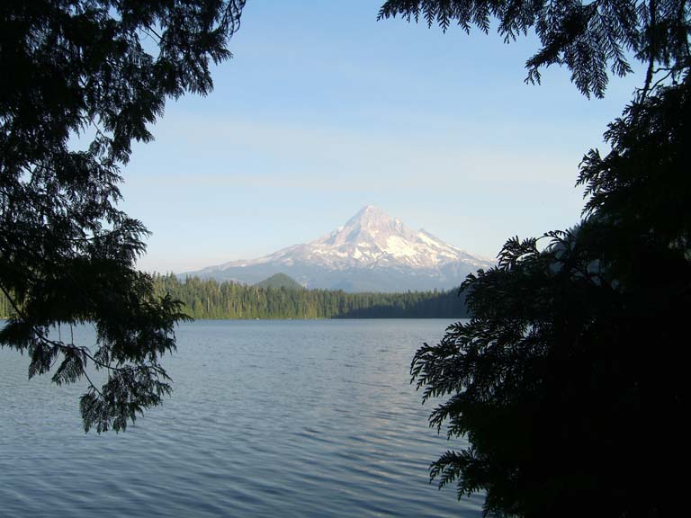
 Leaving the store, we continued around the lake to see the incredible view of Mt. Hood across the lake. There was still a smoke haze though that didn’t keep the view from being incredible. For us, it was even more so as we knew that we had hiked from
 the mountain. We headed on and found the letterbox and returned to camp. Since the lake was the first water we had met that wasn’t ice cold, we took the opportunity to bathe and do some laundry. We stayed pretty modest though that didn’t stop a bunch of high school kids from spying on us. I’m not sure who – or what – they were hoping to see, but I suspect they went away disappointed.
 We went back to Camp Mirage and ate dinner. We wondered about Ryan but figured he must have somehow missed the side trail and that we’d catch up with him the next day. Tired after our longest day, we went to bed.
posted by James Cradit @ 12:57 AM
![]()

0 Comments:
Post a Comment
<< Home